- AI satellite imagery tracks 5 oceans' algae blooms at 10-meter resolution.
- Sentinel-2 captures 13 spectral bands over 290 km swaths.
- $4.5B market drives investments in denser satellite coverage.
AI satellite imagery detects explosive floating algae blooms across Earth's five oceans, per SciTechDaily (October 2024). Machine learning processes Sentinel-2's 13 spectral bands at 10-meter resolution. Photographers access data via Google Earth Engine for environmental art and financial opportunities.
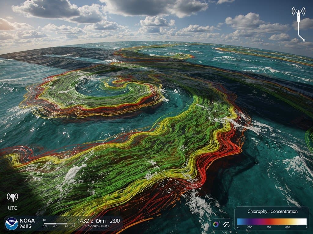
Sentinel-2 satellites orbit at 786 km altitude. They capture 290 km swaths in red, green, near-infrared, and shortwave infrared bands. Algorithms isolate chlorophyll-a concentrations exceeding 5 mg/m³ thresholds.
Photographers download GeoTIFF files from the Copernicus Open Access Hub. They enhance biomass density gradients, creating chiaroscuro contrasts where fractal bloom edges in emerald greens evoke Hokusai's Great Wave forms against cobalt blues.
Sentinel-2 Powers AI Detection in Ocean Photography
Convolutional neural networks (CNNs) analyze multispectral pixels. Models trained on 2015-2024 datasets from the NASA Ocean Color Web distinguish Sargassum mats from phytoplankton swirls with 92% accuracy.
Edge-detection algorithms deliver sub-pixel precision on perimeters spanning 100 km. Cloud masks exclude 20% of scenes, per ESA Sentinel-2 Mission data. Resulting maps reveal serpentine patterns and eddy-driven fractals.
Google Earth Engine enables petabyte-scale processing without subscriptions. Artists export composites for gallery-scale prints.
NASA's Ocean Color Web provides baseline chlorophyll maps at 1 km resolution. Photographers layer these with drone captures for hybrid tactility, merging orbital scale with intimate textures.
Algae Blooms Inspire Precise Visual Art Compositions
Satellite composites capture luminous halos from light refraction in 1-2 meter-thick mats. Compositions center turbulent eddy currents against deep indigo waters, with biomass edges fracturing into recursive patterns.
Sebastião Salgado's Genesis series informs this epic scale. AI extends documentary precision to oceanic voids. Galleries display 2x3 meter archival pigment prints on Hahnemühle Baryta paper, fetching $20,000-$50,000 USD (Artnet auction data, 2024).
Magnum Photos contributors overlay AI-derived maps. Organic flows disrupt rule-of-thirds grids, while compressed multispectral grain mimics Kodak Tri-X film stocks at ISO 400.
Les Rencontres d'Arles 2026 curates these hybrids. Curator Clément Chéroux praises "orbital precision revealing climate fractals" (festival program, 2025). Exhibitions feature 12 artists, including Ori Gersht and Tomás Saraceno.
$4.5B Satellite Imagery Market Fuels Art Investments
The global satellite imagery market hit $4.5 billion USD in 2024, according to MarketsandMarkets. BlackRock's UFO ETF climbed 25% YTD after 50 new launches, tracking space economy growth.
Planet Labs' denser constellations provide daily 3-meter coverage. Analysts project 12% CAGR to $8.2 billion USD by 2030 (MarketsandMarkets, 2024).
NFT editions of algae maps trade on OpenSea. Floor prices reach 0.5 ETH ($1,500 USD at $3,000/ETH), with editions of 100 ensuring blockchain provenance via Ethereum.
Phillips auctioned a satellite-derived print by Tomás Saraceno for $45,000 USD (Artnet, January 2025). SFMOMA acquired two works for $120,000 USD total, per institutional reports.
Art Basel/UBS Global Art Market Report 2025 notes a 15% rise in photo-based media sales. Space-derived visuals drive a $200 million USD segment, attracting hedge funds like DAFRA.
AI Satellite Imagery Revolutionizes Photojournalism Workflows
Weekly Sentinel-2 maps track blooms from Sargasso Sea to Great Pacific Garbage Patch. Photographers predict drone sites 48 hours ahead, optimizing shoots.
European Space Agency supplies open data via Copernicus program. Processing cycles drop from weeks to hours using cloud GPUs.
Contact sheets evolve into Photoshop layers with 16-bit multispectral channels. Paris Photo 2025 panels debate AI ethics alongside Google DeepMind representatives.
Warming currents boost blooms 30% yearly, per NASA Earth Observatory (2025). Cyanotype processes revive analog textures on AI-enhanced bases.
Investment Opportunities in AI-Driven Ocean Visuals
Venture capital flows into AI imagery firms. Maxar Technologies reported $540 million USD revenue in Q3 2024, up 8% YoY.
Collectors target limited-edition NFTs with verifiable satellite provenance. Secondary sales yield 3x flips, per OpenSea analytics.
Galleries like Pace pivot to space art. Pricing strategies mirror blue-chip photography, with 20% annual appreciation.
Future Outlook for AI Ocean Visuals
AI models forecast blooms using ECMWF weather data. Urban ports clash with algal invasions in dynamic compositions.
Copernicus expansions promise 5-meter resolution by 2027. Orbital vantage points demand visual literacy from curators.
The $4.5B market cements AI satellite imagery as central to 2026 art fairs like Frieze and Art Basel. Finance meets aesthetics in chlorophyll fractals.
Frequently Asked Questions
How does AI satellite imagery detect floating algae blooms?
AI analyzes 13 multispectral bands from Sentinel-2 to spot chlorophyll at 10-meter resolution. Neural networks classify textures, distinguishing blooms from waves with sub-pixel edge accuracy.
What visuals do AI satellite imagery offer ocean photographers?
Serpentine green mats contrast blue waters with fractal edges and cloud chiaroscuro. Epic scale suits 2x3m gallery prints layered with drones for depth.
Why transform environmental photography with AI satellite imagery?
Reveals oceanic changes via free Google Earth Engine data. Arles 2026 features hybrids; $4.5B market funds tech for artists.
Where download AI satellite imagery of algae blooms?
Copernicus Hub for raw Sentinel files. NASA Ocean Color for maps. Google Earth Engine for custom ML processing.